Zone 1
Control of Weapons Act 1990
DECLARATION OF DESIGNATED AREA UNDER SECTION 10D(1)
The Assistant Commissioner, North West Metro, acting as a delegate of the Chief Commissioner of Police under section 10D(1) of the Control of Weapons Act 1990, declares as a designated area in all public places within the City of Wyndham that is within the area bounded by and including:
- the intersection of Heaths Road and Morris Road
- to the intersection of Morris Road and Hogan Road
- to the intersection of Hogans Road and Tarneit Road
- to the intersection of Tarneit Road and Heaths Road.
This area includes Pacific Werribee Shopping Plaza, Cambridge reserve, Hoppers Crossing Skate Park and Mossfiel playground.
Road has the same meaning as in section 3 of the Road Safety Act 1986.
This declaration will operate on Friday 14 May from 2pm to Saturday 15 May 2021 at 2am.
Zone 1 map
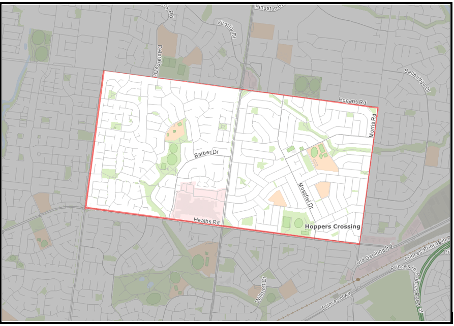
Note: All maps are provided as a guide only. Refer to the Government Gazette written descriptions for accuracy.
ZONE 2
Control of Weapons Act 1990
DECLARATION OF DESIGNATED AREA UNDER SECTION 10D(1)
The Assistant Commissioner, North West Metro, acting as a delegate of the Chief Commissioner of Police under section 10D(1) of the Control of Weapons Act 1990, declares as a designated area in all public places within the City of Wyndham that is within the area bounded by and including:
- Wooten Road and Hogans Road intersection
- to the intersection of Hogans Road and Morris Road
- to the intersection of Morris Road and Leakes Road
- to the intersection of Leakes Road and Skeleton Waterholes Creek, Skeleton Waterholes Creek and Dohertys Road
- to the intersection of Dohertys Road and Sewells Road
- to the intersection of Sewells Road and Sayers Road
- to the intersection of Sayers Road and Babele Road into Wooten Road.
This area includes Tarneit Central Shopping Centre, Tarneit Gardens Shopping Centre, Wyndham Village Shopping Centre and Tarneit Railway Station.
Road has the same meaning as in section 3 of the Road Safety Act 1986.
A map of the designated area can be found below.
This declaration will operate on Saturday 15 May 2021 from 10am to 10pm.
Zone 2 map
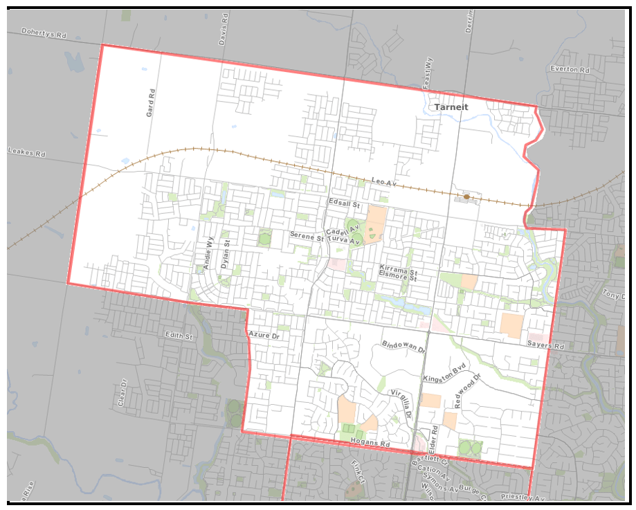
Note: All maps are provided as a guide only. Refer to the Government Gazette written descriptions for accuracy.
Victoria Police powers in designated areas
Police officers and protective service officers (PSOs) are empowered to search a person and anything in the possession or control of the person, or a vehicle, for weapons under the Act. You, your vehicle or things in your possession are in a public place within a designated area.
A police officer or PSO intends to conduct a limited search of you or your vehicle/things:
- You are requested to co-operate with that search.
- You may be requested to remove items of outer clothing such as headwear, scarves, jackets, etc.
- You may be searched using an electronic wand.
- You may be requested to remove items from any bags or pockets.
- You may be given a “pat down” search.
A police officer may also exercise their power under the Act to direct you to leave the designated area if you refuse to remove a face covering.
A police officer may direct you to leave the designated area if they reasonably believe that you intend to engage in conduct that would constitute an affray or violent disorder under s.195H and s.195I of the Crimes Act 1958 respectively.
It is an offence under the Act to obstruct or hinder a police officer or PSO in the exercise of a power to stop and search a person or vehicle or to fail to comply with a direction to leave the designated area.
Public notices
News of past and upcoming Victoria Police operations, and the dates and times of the operations.
Updated