Corrigendum declaration
Corrigendum declaration of designated place under section 3a(2) Planned Operation in Bayside Shopping Centre.
The following amends the notice advertised on the Victoria Police website dated 8 January 2026. The amendment relates to the description and map of the designated place.
Declaration of the Designated Place under section 3A of the Victoria Police Act 2013
The Deputy Commissioner, Regional Operations, acting as a delegate of the Chief Commissioner of Police, has declared under section 3A(2) of the Victoria Police Act 2013 (Act), the following location as a designated place.
The declared designated place will be in effect from 8.00 am on 12 January 2026, to 11.59 pm 28 February 2026 inclusive and relates to Operation Pulse.
I am satisfied of the matters specified in sections 3A(3)(a)-(c) of the Victoria Police Act 2013 in making this declaration.
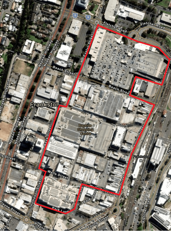
Boundary of the Designated Place
The area that is declared to be a designated place is all public places within Bayside Centre, Frankston being the area bordered by (and inclusive of)
- north to the intersection of Young Street and Beach Street
- west to the intersection of Beach Street and Horne Street
- north and east to the intersection of Horne Street and Dandenong Road West
- north to the roundabout intersection of Dandenong Road West and Fletcher Road
- west to the intersection of Fletcher Road and Evelyn Street
- south to the intersection of Evelyn Street and Beach Street
- continue south to the intersection of Olsen Street and Ross Smith Avenue West
- west to intersection of Ross Smith Avenue West and Keys Street
- south to the intersection of Keys Street and Wells Street
- east to the intersection of Wells Street and Thompson Street
- south to the intersection of Thompson Street and Park Lane
- east and north to the intersection of Park Lane and Wells Street, and
- east to the intersection of Wells Street and Young Street, Frankston.
The map below illustrates the geographical boundaries of the declared Designated Place where Victoria Police Protective Services Officers (PSOs) can be deployed.
Public notices
Past and upcoming Victoria Police declarations under the various statutes, and the relevant dates and locations.
Updated