Declaration of the Designated Area under section 10D (1) of the Control of Weapons Act 1990
The public place area depicted on the map below has been declared to be a Designated Area under section 10D (1) of the Control of Weapons Act 1990 (the Act).
This declaration will be in place from 8.00am to 8.00pm on Sunday 19 October.
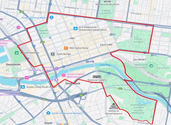
Boundary of the Designated Area
The designated area covers all public places within Melbourne CBD and surrounds, bounded by:
- the intersection of Peel Street and Victoria Street
- east to the intersection of Victoria Parade and Clarendon Street
- south to the intersection of Clarendon Street and Wellington Parade
- west to the intersection of Flinders Street and Batman Avenue
- south-east to the intersection of Batman Avenue and Olympic Boulevard
- west to the intersection of Olympic Boulevard and Alexandra Avenue
- south-east to the intersection of Alexandra Avenue and Anderson Street
- south to the intersection of Anderson Street and Domain Road
- west to the intersection of Domain Road and Birdwood Avenue
- north-west to the intersection of Birdwood Avenue and Anzac Avenue
- west to the intersection of Anzac Avenue and St Kilda Road
- north to the intersection of St Kilda Road and Southbank Boulevard
- west to the intersection of Southbank Boulevard and Yarra Bank Highway / City Road
- south-west to the intersection of Yarra Bank Highway / City Road and Power Street
- north-west to the intersection of Power Street and Queens Bridge Street
- south-west to the intersection of Whiteman Street and Spencer Street / Clarendon Street
- north along Spencer Street / Clarendon Street over the Yarra River to the intersection of Spencer Street and Collins Street
- west to the intersection of Collins Street and Wurundjeri Way
- north to the intersection of Wurundjeri Way and La Trobe Street (including Southern Cross Railway Station and associated bus terminal)
- north-east to the intersection of La Trobe Street and Spencer Street
- north to the intersection of Spencer Street and Dudley Street
- east to the roundabout intersection of Dudley Street and Peel Street
- and north to the intersection of Peel Street and Victoria Street.
The designated area includes all roadways and footpaths associated with the stated road and road related areas. Road has the same meaning as in section 3 of the Road Safety Act 1986.
Victoria Police powers in designated areas
Police officers and protective service officers (PSOs) are empowered to search a person and anything in the possession or control of the person, or a vehicle, for weapons under the Act.
You, your vehicle or things in your possession are in a public place within a designated area.
A police officer or PSO intends to conduct a limited search of you or your vehicle/things:
- You are requested to co-operate with that search.
- You may be requested to remove items of outer clothing such as headwear, scarves, jackets, etc.
- You may be searched using an electronic wand.
- You may be requested to remove items from any bags or pockets.
- You may be given a “pat down” search.
A police officer may also exercise their power under the Act to direct you to leave the designated area if you refuse to remove a face covering.
A police officer may direct you to leave the designated area if they reasonably believe that you intend to engage in conduct that would constitute an affray or violent disorder under s.195H and s.195I of the Crimes Act 1958 respectively.
It is an offence under the Act to obstruct or hinder a police officer or PSO in the exercise of a power to stop and search a person or vehicle or to fail to comply with a direction to leave the designated area.
Public notices
Past and upcoming Victoria Police declarations under the various statutes, and the relevant dates and locations.
Updated